
New Zealand -Walks & Sightseeing
- Jocelyn Timmermans

- Feb 20, 2023
- 14 min read
January 19 - February 10, 2023
I've been told New Zealand is a lot like our BC. The moutains and the ocean, yes. But the tropical vegetation and volcanoes, no. We were warned about the ever changable weather, especially in the Alps. Little did we realize what we were in for: their wettest summer on record! We were on the South Island when the flooding of the Auckland airport in the north became global news, four days after we arrived. Not only that, but after we flew home, we missed Cyclone Gabrielle by three days, which was declared a "national state of emergency", only the third in New Zealand's history. Add to that the ferry that broke down two days before we had to cross and the landslide that cut off the beautiful trail to Cathedral Cove the very next day after we hiked it! So we're thankful we got to stick to our loaded itinerary as planned.
Us four ladies made a great team. I had put together the itinerary, Janice reserved all the campsites and tours and was real good at packing all our big backpacks and small suitcases into the small space in the back of our car, Denise and Wendy did all the driving (on the right side) and navigating and I documented & photographed the trip.
We did our trip from south to north, from the remote mountainous regions in the south island to the volcanic hot spots in the north island. From nature and hiking enthusiasts to tourists and sightseeing. From tents to hostels and ending with some luxury wining & dining in the big city where a third of New Zealand's population resides.
It was a full-blown adventure, in more ways than one.


Jan. 19 - 21: Wendy & I flew a total of 14 hours on Air New Zealand, with a stop-over in Los Angeles, arriving in Auckland at 6:00am. The Ibis Budget Hotel hotel was a 10-minute walk from the airport and we could leave our airport cart there. Janice arrived later in the morning.

We took a taxi to the center of the city, to visit the Winter Gardens, established in 1913.


Silver Cockscomb.

Blooming Magnolia tree.


1) The Sweetbay Magnolia blossoms. 2) Flame Lily


1) Rimu tree 2) Totara tree


Fallen but still living.

A ficus tree.


Close to the gardens is the 328m high Sky Tower built in 1997.


And he jumped!!! Notice the three cables that minimize how far he swings.


1) An inquisitive seagull. 2) Montebretia - these grew in abundance along the roadsides.
Jan. 22: Not wanting to spend more money on a taxi, we searched for somewhere to go that would be within walking distance. We ended up walking about 15 km return (mostly on road) to the historical Stone Hedge site. I learned quite quickly how harsh the sun can be, suffering a sunburn to my legs and shoulders. I was glad I threw that long-sleeved cotton blouse in my backpack at the last minute. I ended up wearing it alot.We were quite limited as to how much we could take along for a backpack trip, sightseeing, and walks in all sorts of weather. Everything had to fit into our overnight backpacks except for 7 kg in our carry-on luggage. So I thought I'd buy the sunscreen in New Zealand. After this day, I didn't go anywhere without it. Fortunately the temperatures stayed in the 20s so getting wet wasn't as big a deal.

This Octuatuana settlement was built on volcanic maunga by the people of Waiohua. Pits and lava tubes in this area were used for ancient Maori burial sites. The rock walls that were built on higher ground overlooking the harbour, were used as protection from enemies and also for vegetable gardens that were fed by fresh water springs.


1) African Lily 2) Dates

An advocado orchard.


A seashell beach in Manukau Harbour.


1) Rata 2) Morning Glory 3) Balloon Cotton Bush

The only clothes shopping we did -- without spending money! Wendy & Janice were pretty happy with their shirts that would protect them from the sun.

We met up with Denise at the airport and immediately checked in for the 1 1/2 hour flight to Queenstown. We stayed at the Aspen Hostel that night and did not go back as planned after the backpack trip. The whole place was run down and not all rooms were accessable from a hallway so our room became somewhat of a thoroughfare for the ladies in the next room to get to the kitchen.
Jan. 23 - 26: The Routeburn trek + Milford Sound. Check in my other blog on Trekking in New Zealand
The night of the 26th we stayed in Eglinton Valley at Knobs Flat campsite. There we could do our laundry, dry our tents out in the sun and prepare dinner. Denise had fallen and injured her hip a few weeks before the trip. So carrying an overnight backpack was not an option for her. Her plan was to buy groceries for dinner for when we returned from our backpack trip, and go on a helicopter ride. The latter never happened because she ended up getting sick with a nasty flu that left her sleeping all day. Thankfully that was the last of her misshaps and she was able to join us on all outings for the remainder of the trip.

After four consecutive days of hiking, we were glad to have a nice hostel in the heart of Queenstown: the Absolute Hostel. I ate mostly prepackaged salads with a tin of beans for dinner.


We needed to dry our tents that were still wet from dew the night before. In this small town with umpteen outdoor clothing and gear stores, this didn't look out of place at all.


It took a few days to get into the rhythm of unpacking, packing, remembering what items you put into which pockets, buying groceries and charging phones & batteries. I learned to stock up on food and use the restrooms when available.
Jan. 27: This was a full day of driving, about 8 hours. First to the coast east of Queenstown and then northwest to Mt. Aoraki / Mt. Cook National Park.

The Moeraki Boulders on Koekohe beach. Why are they so round?
Scientists have often wondered why these hardened masses of carbonate formed around dead organisms, with round shapes and sharp boundaries with the surrounding material, typically in marine mud and mudstone. Contrary to former belief, its now recognized that the balls form fast, in under two years.


These Elephant Rocks were used as a filming location for the first Chronicles of Narnia movie in 2005.

This limetone was first exposed in large unbroken sheets by tectonic proccesses. Erosion by wind, rain and ice left behind these isolated "elephants".


The Clay Cliffs.

Box canyons, towers & pinnacles are the result of a sequence of weak sedimentary deposits. The grey and white sandstone & siltstone were formed in an ancient lake that once existed here and the yellow & brown gravel conglomerate with silt layers were deposited by an ancient river.


A viewpoint off of the road with Mt. Cook (3724m) being the highest peak.

Lake Pukak along Hwy. 80.


We stayed at the Hermitage Hotel for two nights (lower left). Mt. Sefton (3151m).

Did a quick grunt up to Tasman Lake to catch the sunset.


Mt. Sefton & Mt. Cook. A large monument of Sir Edmund Hillary stands infront of the Hertmitage Hotel. On May 29, 1953 he became the first mountaineer to summit Mt. Everest. He trained on Mt. Cook.


Jan. 28: We hiked up to the Mueller Hut. (in my other blog).
Jan. 29: With a forecast of rain for the next days, we decided to attempt Avalanche Peak a day earlier.
So we drove four hours to Aurthor Pass where we stayed two nights at the Aurthor Pass Motel. We started hiking at 3:00pm. (in my other blog).
Jan. 30: We were now to embark on a different phase in our journey. With all but one of the hikes behind us and a change in the forecast from sun & cloud to rain & cloud, we headed for the west coast, as planned. This weather stuck around for the next eight days, off & on. We were thankful to have missed the flooding in the north part of the north island. It had rained 245mm in one day! In less than one hour on the 27th, Auckland got more than its monthly record of rain. It was not only Auckland's wettest month on record, but also it's wettest January on record.


Rata vines covered tree trunks. How fitting to have rain during our rain forest walk through the Hokitika Gorge. Normally the river is a vivid turquoise color but because of the heavy rainfall and rushing churning water, it was a murky dull grey.


The track (trail) took us through a mature podocarp and hardwood forest.

The Alpine Fault lies about 200 km beneath New Zealand. It's where the Australian & Pacific plates meet. This is what created the Southern Alps and what causes the earthquakes and landslides. It pushes up the Southern Alps by 10-20mm annually.


The wettest place in New Zealand is west of the Southern Alps and 10km north from this gorge, by the Cropp River where they get an average of 12m of rain a year.


Black Tree Ferns provided a canopy.


Rimu.

Flaxlily.
We had to drive all the way up and then down the west coast, doing a narrow 3 1/2-hour horseshoe to get to these two glaciers. Clouds abscured the view and we didn't have time to leave the path and get closer to the glacier.

The 15-minute walk to this viewpoint got us 3000m from the toe of the Franz Josef Glacier.


The Fox Glacer walk was a 45 minute return walk.


1) Spotted Felt Lichen 2) Ochre Bracket

This viewpoint got us to within 2600m of the Fox Glacier.


We spent the night in the Franz Glacier Village hotel. This day we had driven a total of 3 1/2 hours.
Jan. 31: We now drove north along the west coast and checked out this driftwood competition in Hokitika.

This kiwi got first prize from the public.


Motukiekie beach walk to sea stacks.


Boulders made up of stones and home to clams.

An Oyster Catcher started diving towards Janice's head. She got too close to it's nest.


Pancake Rocks in Punakaiki.


When the tide is high, this blow-hole comes to life.


A Weka.


The Truma track.


Kiekie finding a home on the tree's trunk.


The Ballroom.


Limestone carved by the sea.


This was our smallest hut for four, at the Kaikoura Beach holiday park where we stayed two nights. . Because of the wet weather, we upgraded to this tiny cubicle, as ended up happening for the remainder of the trip. Most of the campsites offered this option for only $20.00 or so more. They were much like a hostel where there were communal kitchens and bathrooms.

Ahhh. The Cecadias! For a small bug, they made a big noise! It was worst at this location. We had to keep our window closed at night which wasn't very nice when our hut was so warm. They can sound like electrical wires that are short-circuiting. This day we had driven a total of 3 hours.
Feb. 1: Foulwind, so named by James Cook in March 1770, is a 2-hour coastal walk.


A Fur seal colony in Tauranga Bay.

There were two pups trying to scramble up to their parents (right).


There were not many shipwrecks on Cape Foulwind despite it's dangerous shoreline and treacherous winds. The first lighthouse was built here in 1876.


Plenty of flax plants were growing here.
A solo evening stroll along the beach by our campsite.


Pied Shag bird.

Feb. 2: We started the day with a 2:40 hour drive to Abel Tasman National Park. In 1642 a Dutch seafarer named Abel Tasman first sighted this coast. As we got closer to the northern part of the south island, there was more human habitation. Instead of rolling hills with sheep & cattle, there was more cultivated land; fields of hemp, corn, vineyards and fruit trees.

Almost all houses were only one story high and small. Later we learned that this is because of the constant earthquakes and the heat. They're built on blocks or stilts.

The next two nights we stayed at The Barn hostel.


Janice & I went on an evening stroll a hop & a skip from our campsite.


These pine cones were the size of goose eggs.


Pukeko


We saw a whole herd of these cows with the white band round their middle.
Feb. 3: We took a water-taxi up the coast from Marahau to Totaranis. There's also a multi-day trek along this stretch of coast. Then we were dropped off at Anchorage Bay for three hours. Denise got her wish and the sun came out. After my first-day sunburn, I wasn't going to take any chances. So I spent more time lying in the shade than in the hot sun.


Split Apple Rock.

A family of Fur seals. Baby had just plunged into the water. Mom is to the left and father to the right.


See you later, boat.


We were wondering when we drove into the village, what those tractors with utility trailers were doing parked by the water? Upon our return, we found out: they were loading up our people-filled boats and pulling us back to the parking area.
Feb. 4: This day involved the inter-island 3-hour ferry crossover. We got up at 5:30am. Just two days prior, it was on the news that the ferry broke down. Again, we just missed not being able to cross.

There are over 26 million sheep in New Zealand having declined from 70 million in the 1980s. There's 5.12 million people living in New Zealand.

Approaching a narrow passageway.

The ferry went from Picton to Wellington. This was a very different scene than what we saw on the south island. The north island had much more human habitiation, tourists and a better infrastructure.

A windmill in New Zealand? I soon came to realize that from Abel Tasman NP and on north, there were alot of Dutch and German tourists. Apparently in the middle of the 19th century, a few Dutch people settled in New Zealand but by the 1874 census, only 127 of the 300,000 settlers recorded, were of Dutch birth.


The Makatote viaduct was the last and highest structure completed on the North Island Main Trunk railway. It ran from Auckland to Christchurch and was a critical part of KiwiRails network. It was built 1905-1908, is 79m high and 262m long.

The base of a mountain range by the Tangariro Alpine Crossing trail.

Mt. Ngauruhoe (also known as Mt. Doom in the Lord of the Rings movie) was where we hiked the following day. We stayed at the Discovery Lodge for two nights. The two-person huts were muffy and tiny. But the location was close to the trailhead and provided a 10-minute bus ride to the trailhead the next morning + a pickup later, on the hour in the afternoon.
Feb. 5: The Tangariro Alpine Crossing (in my other blog).
Feb. 6: Wake up call at 5:50am. After 1 1/2 hours driving we arrived at these sights:


The raging Huka Falls.

A 5-minute boat ride took us to the Orakei Korako geothermal park.

"With My Two Feet"

This is a 2.5 km long loop track.


A boiling, bubbling and burping mud pool.

This is one of only two geothermal caves on the planet.


1) Honeysuckle 2) Pouched Coral Fern

Feb. 6: Knowing this would be a full day, we got up at 5:50am.
We started with a 1-hour walk by the Waitomo Glow Worm Caves.

We soon found out this was not the trail we intended to take. It was very muddy and slippery in spots. We learned later that the Ruatapu bush walk was inaccessible due to a land slide.


Australian Daisy.


Unfortunately, I was not allowed to take photos in the caves. Titiwai glow worms are the larval stage of New Zealand's Fungus Gnat. The glow worms live 9 months, they lay eggs that hatch into flies and then eat the flies. They can live off of one fly for 3 months.

The first part of the tour brought us through hugh chambers with stalactites and stalagmites. Then we got into a small boat that was quietly pulled along by hand on cables in the dark where the glow worms looked like stars in the night sky.


We saw several of these deer farms along the road.

We stayed one night in the Horse & Jock hotel in Matamata. It was rather run down but was close to Hobbit Town.
Feb. 7: The Hobbit tour.


There are 39 Hobbit houses in this area, all built at different scales. The tree (top centre) is false. You really have to look hard to see that. It has 250,000 leaves that were wired to the branches and spray painted individually.


May the power be with you!


Cider & beer, on the house!


We got to our campsite / hut for the night at Rotorua Thermal Holiday Park. I opted to walk across the highway and do a tour at the Te Puie Geothermal Park while the others enjoyed a soak in the hotpools at the campsite.


Our little train stopped so we could watch the southern hemisphere's largest geyser; Pohutu's powerful burst (20x daily, up to 30m high).

The Kiwi is New Zealand's national bird. They're nocturnal and have the largest egg in proportion to their bodies (60%). They're an endangered species and mate for life. I got to see three of them close up (no photographs allowed) in the National Kiwi Hatchery.


Our last viewing was of the Maori Art and Craft Institute, where masters of the traditional Maori art form are based.


The first section houses objects made of greenstone & bone.

The second section is wood work.


And the third section is of flax weaving.
The Matai Maori Tour.

In the evening we did a tour of the Maori culture, followed by a dinner. This lady did a fine job of explaining and answering questions about her ancient culture. Here they're roasting lamb, chicken and potatoes in a pit.


We waited in the approaching dark and heard the loud rhythmic chant before we saw the Maori warriors glide into the creek, oars dipping into the water in perfect sync with one another.


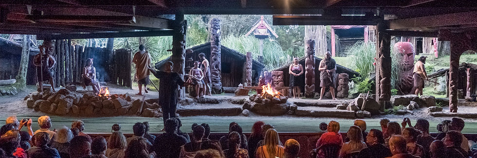
Their performance was amazing! The gutteral cries and ugly faces they pulled; sticking out their tongues with threatening bulging eyes, was their way of preparing for battle.
Feb. 8: We drove 3 hours to Cormondel National Park.

Our room at the Hahai Beach Resort & Campsite, wasn't ready yet so we hung out at the hot-water beach for an hour or so. There's only one spot on the beach where it's really hot, and that's right infront of the protruding rock to the left. It is best experienced by digging a hole in the sand within a few hours of low tide.


Later in the afternoon we did a 3-hour walk on the popular track to Cathedral Cove. The very next day there was a landslide which closed down this trail.


A mama pheasant and her chick.


A side trail to Gemstone Bay led to us to an area that is great for snorkelling.

A second side trail to Stringray Bay, led to this overlook.

Cathedral Cove and the famous Te Hoho Rock.


I went alone to the lookout beyond Cathedral Cove.


Back at the main beach infront of our campsite.


Lily. Hibiscus - they were only blooming in this area.

Dinner.
Feb. 9: We turned right off of Hwy. 25 onto the 309 Road because of a road closure. The Waipoua Forest is the domain of New Zealand's largest Kauri tree: 51.5m tall / trunk diameter is 13.77m! / 1200 - 2000 years old!


Awesome! 2) A Siamese Kauri tree because it's joined at the trunk.

Waiau Falls, just 3 minutes walk from a road-side pullout.

This 309 Road was a rather dangerous narrow winding gravel road to drive. You often couldn't see what was coming around the corner.

We did a pit stop here. This waterwork park is geared more for children.


Manaia Road lookout.


Hey! As we were walking through the harbour in Auckland we saw this boat, named after Janice!
We stayed one night in the Quest Hotel.


It was sort of an off-hand joke between us women, about going dancing on our last night in New Zealand. But as we walked by this restaurant, we heard an upbeat band playing music from our era. The others convinced me to go in but I assured them that I wouldn't dance. I was wearing smelly clothes, none of us having done laundry for almost a week. And my sandle had been broken for days, the sole had separated and was flapping around on my foot. But my conviction to not dance didn't last long. My feet had a will of their own and we ended up indeed, spending our last evening dancing until the band was done. What a great way to end our stay.

When I hesitantly stood on the scale at home, I was surprised to see I hadn't gained any weight! After indugling in all those delicious baked goods (especially in the last week), I fully expected to have put on a few pounds. But our constant activities and packed agenda had kept us moving.

Breakfast, a historical site to see and then a bit of shopping yet (New Zealnd T-shirts for my 11 grandbabies) before boarding our plane.

Maungawhau was one of the largest and most elaborate Maori settlements in New Zealand, home to thousands of people. There are about 50 volcanes in Auckland. What was once a heavily forested area of valleys and headlands, became filled with tuff and magma flow from eruptions, thus creating the landscape seen today.

The crater to the right is spiritual ground for the Maori.


There we two large cruise ships parked in Auckland's harbour.

Splurging on a few drinks before the long flight.

We had a direct 12-hour flight home. Wendy & I had two empty seats beside us so we could lie down and sleep. That and the 178 minute Lord of the Rings movie, made the time fly.
It was so neat to see Hobbit town and Mt. Doom on the TV when I'd just been there in person.

Comments