
Elk-Thurston-Gloria Crossover
- Jocelyn Timmermans

- Oct 31, 2025
- 3 min read
October 30, 2025 -- Chilliwack
Stats: 19.9 km / 1607m gain / 1875m loss / 1590m highest point / 8 hours MT
This hike was a true test of endurance. Therefore I opted to go with the more relaxed paced group of 5 that started at the Elk Mt. trailhead. The other group of 7 started at the Gloria Mt trailhead which is 255m lower than Elk's trailhead. We ended up meeting eachother in the middle of the Thurston - Gloria connecting trail which is where we swapped keys. Brigitte's stats for their group were: 18.5 km / 1795m gain.
Throughout the day we got bits and pieces of views which in total came to a 360 degree view that stretched all the way to the Pacific Ocean, the mountains in Whistler and even in the Coquihalla.

We started hiking at 7:15 am. For the first half an hour we had to use our head-lights.

Mt. Baker and Chilliwack River Valley -- south.

The early morning sky was so clear that we could see the skyscrapers of Vancouver!

Approaching the Elk summit (1440m).

Mt. McGuire + Mt. Baker -- south.

Cultus Lake to the left and Sumas Prairie to the right.

This is also a popular paraglider launch. Slesse & the Border Peaks -- east. I strapped my micro-spikes on here and kept them on for the remainder of the hike. We'd done half of our elevation gain (835m).

Mt. Baker

Bearberry

It took almost one hour to hike the ridge from Elk to the Thurston cairn.


east

The Border Peaks + Tomyhoi -- southeast.

Tomyhoi, McGuire & Mt. Baker -- south. I've summited all three.

Looking back at Elk Mt -- northwest. Robie Reid & Judge Howay were prominent on the horizon to the right.

The Thurston summit is the peak to the far left.


This viewpoint was slighty off trail, just below the Thurston summit which had no view. Slesse, Border Peaks, TomyHoi, McGuire + Mt. Baker.

Group shot: Denise D, Iraj F, Lorenz B, Cindy W + me

The Cheam Range -- northeast.

Approaching Thurston.


At the Thurston summit junction (1590m) which was the highest point on the route.

It was a pretty steep 240m drop to the low point of the Gloria-Thurston connector trail. This north-facing slope had about 1' of snow. Later I heard other group was pretty glad we broke trail for them.
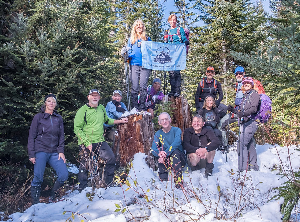
A group shot of both groups, L to R, back row: me, Fred H, Mary R, Brigitte G, Heather F, Sheri K, Iraj F, Denise D, Lorena B Front row: David G (thanks for organizing this hike), Stelian A + Cindy W

A final view to the southeast before reaching the Gloria Mt Summit which is only 30m lower than the Thurston summit = 210m ascent from the low point.

Looking back at the ridge we hiked. Thurston Mt to the right -- southeast.


Us three women went to the Gloria lookout while the guys had a nice rest at this junction.

It was a 150m descent to the Gloria lookout -- northwest.

Sumas Praire with the city of Chilliwack below us -- north.
Harrison Lake (middle) and Agassiz -- northeast.

Harrison Lake (far center) and Agassiz -- northeast.

Mt. Cheam + Lady Peak -- east.


Bracing ourselves for a long 1035m steep descent.


Bear's Head Angel Wings


This spine of land that follows alongside Ford Creek, was the steepest part of the descent.
We got to the parking lot at 4:25pm. We all met once again at the old Canadian Tire store. The other group had arrived there 20 minutes earlier. Not bad timing for such a long day.


Comments