
Tofino - day hikes
- Jocelyn Timmermans

- Jun 17, 2025
- 4 min read
June 5-8, 2025 -- Vancouver Island
I had just gone to Vernon to look into buying a used Winnebago RV and was home only one day before four of us set off for Tofino. On this west coast that gets 3295mm of rainfall annually, we were very fortunate to have four consecutive days of sunshine. We were all excited to take my new used RV on it's maiden voyage and slept comfortably with four adults. Because I didn't know what vehicle I'd be taking on the ferry, by the time I tried reserve I was too late. The person at the payment booth said we'd make the 12:00pm, not the 10:00am. But the line kept moving and we kept hoping and were letting out yelps of victory when we got the hand signal to proceed. We were the last RV allowed on the ferry!

We arrived in Tofino by mid afternoon. Just enough time to do the short 3km walk to the Cox Bay lookout. Ahhh -- it always feels good to be on the rugged raw west coast by the mighty, intimidating ever-changing ocean.


The walk soon turned into a combination hike & scramble. Charlotte made a wise choice when she said she'd stay on the beach because she didn't want to get her white sneakers dirty.

Bog required a bit of balancing.


Roots were often high above the ground. Why? Because the trees grow on fallen nursery logs, due to lack of soil which is due to erosion caused by wind and rain. Then when the nursery log rots and returns to the earth, the roots remain suspended, reminding me of fingers reaching down.

At the viewspoint -- north.


Back on the beach. There was some filming going on involving surfers.


Yummy! No wonder Tacofino is so popular. The fish tacos were amazing!
Day 2: A 6-hour tour ($229.00) to Sharp Point Hotsprings in Clayoquot Sound, Maquinna Provincial Park.


Bye bye Tofino.

Lone Cone Mt, our destination for the next day.


Our boat was the orange one.


Gigantic cedars along a 30-minute long boardwalk that led to the hotsprings.

Bunchberry Dogwood.


About 5-8 liters of water is discharged every second. The hotspring is a result of surface water flowing through a "fault" to a depth of about 5km. The water is geothermically heated to 109C before hydrostatic pressure forces it back up and discharges it at about 50C.

The highest level was too hot to sit in.

The lowest level allowed a trickle of cold ocean water in but didn't have room for more than two people.


The medium level was just right, obviously so. First Nations allow only one boat per day where-as their own company yo-yos people back and forth all day.


A family of sea otters. As we were passing one by, our guide pointed at it and it waved back!

Our campsite was only a few minutes walk to Mackenzie Beach. After dinner we did another evening stroll.


Day 3: Lone Cone Mt - on Mearse Island.
Stats: 6.1 km / 714m gain / 714m high / 2 hours MT to summit

We woke to fog but I wasn't concerned. The forecast called for clear skies. We took this 10-minute water-taxi to Mearse Island.

The first stretch was fairly flat and wound through bog. The trail was rough, rooty and very steep after the first km. It's a good thing it was well flagged because sometimes it wasn't clear to see.

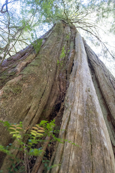
Wow wee!!! Monster trees! There were three of them. Beyond the third one the steep climb began. On the other side of Mearse Island there's a 3km trail by which about 8 of these monsters live. Its a much more popular trail than this one, and for good reason.


Amazing views from the top. Tofino to the left and fog stubbornly clinging to the islands on the horizon.

Sue A, me, Denise D + Charlotte H


There were only two pickup times. Ours was at 3:30pm That gave us half an hour to wait and explore and talk at the dock.


Charlotte was our chef for dinners. She also did most of the driving. Sue loved doing the dishes and cleaning up. I planned and documented the trip.


Of course we went back to the ocean for our after dinner stroll as the sun set.

Day 4: On our last day we drove to Euclulet, stopping along the way at Long Beach.


At the Kisitis visitor center by Wickaninnish Beach, there was much to learn and see.

This sea otter skeleton washed ashore on the beach in 2008. It was the first seen in this area since the last one was shot in 1929.

Grey whales slurp up mud from the ocean floor. They don't have teeth but plates that hang from their upper jaw and act as sieves to serparate the food from the mud.


We did the 2.6 km lighthouse loop trail in Euclulet, which is part of the Wild Pacific trail. Rainforest at its best.

There were many viewpoints along this trail. There were also many people using it.


This stretch of the west coast is also known as the Graveyard of the Pacific, having documented hundreds of shipwrecks. Amphritite Lighthouse was built in 1915.


Many of the trees here are shaped and slanted by the wind.


Quote: Recipe for a coastal temperate rainforest: -start with land next to the ocean -sprinkle with at least 3 m of rain each year, hold the snow & freezing temperatures -add trees of all ages, from tiny saplings to centuries-old giants and layer with mosses, ferns, shrubs & lichens -stir for centuries


By Port Alberni we stopped by this river for a snack. It felt like a sauna outside! It was about 30C! No time for a dip as we had to catch the 6:20pm ferry...


Comments